
When it comes to fixing the Brooklyn-Queens Expressway (BQE), pick your poison.
Last night, hundreds of local residents packed into the Plymouth Church, 57 Orange Street in Brooklyn Heights to hear three community proposals for fixing the BQE to add to the two the city already proposed.
The Brooklyn Heights Association (BHA) and A Better Way (ABW) NYC hosted the town hall as a way for local residents and community leaders to give their opposing proposals to the DOT’s plans for upgrading a 1.5 mile stretch of deteriorating roadway between Atlantic Avenue and Sands Street.
First up was The Temporary Parallel Bypass Method presented by Marc Wouter Studio in conjunction with the BHA that includes a free-standing, two level, temporary structure constructed parallel to the BQE. The hybrid construction concept combines bypass, traditional lane-by-lane and at-grade reconstruction for maximum efficiency according to the proposal.
Marc Wouter Studio’s went on to note that this plan’s benefit is that work can be done in segments that can be engineered and completed independently allowing for minimal closure of the Brooklyn Heights Promenade.
Next up was The “Tri-Line” Lane by local resident and avid jogger Mark Baker that would add eight acres of parkland on top of the highway.
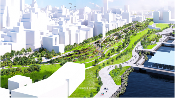
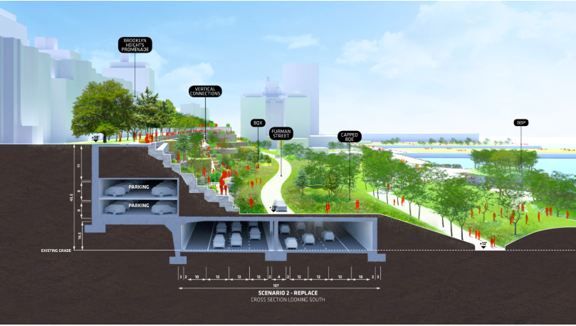
However, the night’s highlight seemed to be the unveiling of the newest proposal for consideration dubbed the “BQP – turning the BQ-Expressway into a BQ-Park – by Jeremy Siegel with Bjarke Ingels Group. The firm wants to build a new, six-lane highway that would be topped by a public park, saving the promenade and expanding Brooklyn Bridge Park by more than 10 acres.
“The proposal includes construction of an at-grade roadway along Furman Street and Brooklyn Bridge Park, covered with simple deck structure. The deck provides a platform form adding significant new parkland along an underused corridor while connecting Brooklyn Heights to Brooklyn Bridge Park with a preserved or reconstructed cliffside-crisscrossed by rampways, greenery and park amenities. Local park access is accommodated on the meandering parkway, while space is created for a potential spur of the BQX light-rail line. The deck structure extends south to Atlantic Avenue-where it creates a new crossing and urban nexus and the beginnings of a linear park which could eventually connect DUMBO to Red Hook. The simple structural approach and one-time construction of the new roadway, create a more feasible and less costly solution for reconstruction of the BQE, while delivering far more benefits to the community,” according to the plan.
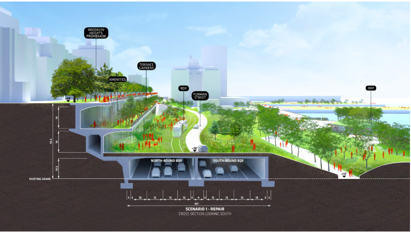
BIG’s plan offers two scenarios: to repair the BQE existing triple-cantilever structure and turn it into a linear park connecting to the Brooklyn Heights Promenade, or to replace it with infrastructure ready to support a variety of uses, including the possibility of housing or retail, or more parkland.
Siegel was met with applause throughout the presentation particularly when it came to the proposal’s potential for extending the park space and walking access in the area.
“Also looking into the future, when and not if, when the BQE is capped along Cobble Hill, this plan would create the beginnings of a linear park and eventually connect DUMBO to Red Hook,” noted Siegel.
Head engineer of the BQP plan, Peter Glouse echoed this sentiment as he went over the benefits of the plan.
“The finished product is an open space, a landscape, a neighborhood extension. As opposed to a triple-decker traffic conveying system, which is a totally different thing,” said Glouse.
The proposals come on the heels of Mayor Bill de Blasio hitting the brakes on a $3 billion DOT plan and instead convening a “panel of experts” to determine the best path forward.


Brooklyn Borough President Eric L. Adams, NYC Comptroller Scott Stringer and City Councilman Stephen Levin (D-Williamsburg, Vinegar Hill, Brooklyn Heights, Carroll Gardens, Boerum Hill, Cobble Hill, DUMBO, and parts of Bedford-Stuyvesant, Clinton Hill, Greenpoint, Downtown Brooklyn, Gowanus, Park Slope) applauded the evenings presentations hinting at them being the first steps of a healthy solution.
“You know my position is clear and it probably goes beyond the position of others. When you talk about reshaping highways. This is not just a political stance, this is a personal stance. It’s about how do we define ourselves. How do we reverse the destruction of Robert Moses,” said Adams.
“The bottom line is that we want choice. That is what community-based planning is all about. Tonight you are going to hear a new proposal from a professional architecture firm that will show you compelling renderings and offer yet another vision,” said Stringer.
“The plans that we saw tonight are really remarkable and it shows what we can do when we’re inspired. But we have to have a consensus plan. Not because it is the right thing to do but if we do not have a consensus, there will be no plan because it can’t move forward. If we don’t have a consensus plan, I don’t see how it’s able to get through the review process in the City Council,” said Levin.
According to DOT, significant repairs and replacements will have to be made by 2026 when vehicle-weight limits and truck diversions will be necessary because of deterioration to the structure.